
Urban Heat Island Effect: Why Cities Stay Hotter
The urban heat island effect is why one block can feel like a held breath while the park three minutes away feels merely warm. The Sun did not choose your street personally. The difference is the street: asphalt, roof membranes, brick, concrete, parked cars, missing shade, and air conditioners pushing indoor heat outdoors. A city does not just receive a hot day. It stores it and releases it after sunset.
TL;DR
The urban heat island effect happens when dense built surfaces absorb and re-emit more heat than trees, soil, and water. EPA summarizes U.S. urban air temperatures as about 1-7 degrees F warmer during the day and 2-5 degrees F warmer at night than outlying areas, with surface temperatures varying even more. The danger is not only the afternoon peak; warm nights can keep bodies and buildings from recovering.
Short answer: cities stay hotter because dark, dry, hard materials take in solar energy, buildings trap wind and radiation, vegetation is removed, and human activity adds waste heat. The result is measurable from sidewalks and satellites, which is why agencies such as the EPA, USGS, NOAA, and NASA use local sensors and thermal imagery to map city heat.
Curious? Try one 👇
Why is the sky blue?
Jump into the daily quiz →The temperature difference is real, but the number depends on what you measure
The first trap is asking for one number. Heat islands can mean air temperature, land surface temperature, nighttime temperature, or one roof compared with air. EPA says U.S. urban air temperatures are commonly about 1-7 degrees F higher than outlying areas in the day and about 2-5 degrees F higher at night. EPA also notes that conventional roofing materials on a warm day can reach as much as 66 degrees F warmer than surrounding air temperature (EPA Heat Islands).
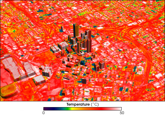
That is why a satellite image can look dramatic while a weather station gives a smaller number. A thermal satellite sees land surface temperature: the hot roof, the road, the parking lot. A thermometer at human height measures air temperature, mixed by wind, shade, humidity, and time of day. Surface temperature shows where heat is stored; air temperature shows what people breathe and what buildings have to cool.
USGS recently characterized surface urban heat islands across 50 major U.S. cities using Landsat thermal data from 1985 to 2020. Its fact sheet reports an average surface urban heat island intensity of 2.88 degrees C, or 5.19 degrees F, and notes that 47 of 50 cities had a positive warming effect (USGS Fact Sheet 2023-3048). The practical lesson is simple: the heat island is visible in pixels.

Asphalt and concrete are slow heat batteries
Walk barefoot from grass to blacktop and your feet know the physics before your vocabulary does. Asphalt and many roofing materials have low albedo, which means they reflect less sunlight and absorb more energy. They are dry and dense, so they do not cool themselves by evaporating water the way soil and leaves can. During the day, those materials charge up. After sunset, they discharge into the air around them.
EPA's mechanism list is blunt: buildings, roads, roofs, sidewalks, and parking lots absorb and re-emit heat more than forests and water bodies. Heat islands often build through the day and become more pronounced after sunset because urban materials release heat slowly (EPA). That is why it can still feel hot at 10 p.m.: the city is giving back the afternoon.
City geometry adds another layer. Tall buildings and narrow streets make urban canyons. They reduce wind, interrupt the view of the sky, and give heat more surfaces to bounce among before escaping. A neighborhood full of hard, dark, wind-blocking surfaces becomes less like open air and more like a storage system.

Missing trees remove the city's cooling machinery
Trees cool cities in two ways. The obvious one is shade: they stop sunlight from reaching pavement, roofs, walls, and skin. The less obvious one is transpiration. Leaves move water from roots to air, and that phase change carries heat away. When a block loses trees, it loses both the umbrella and the evaporative cooling system.
EPA calls trees and vegetation a simple and effective heat-island reduction strategy because they provide shade, transpire water, and support cooler local air (EPA Trees and Vegetation). This explains why heat maps inside the same city can look unfair. Two neighborhoods may share the same forecast, but the one with fewer trees and more pavement often feels like a different microclimate.
NOAA's urban heat-mapping campaigns make that unfairness measurable. The agency has worked with local partners and community scientists to map urban heat islands, because temperature can vary sharply across streets, parks, industrial corridors, and residential areas (NOAA). The thermometer becomes a civic instrument: it shows where the city designed extra heat into daily life.

Waste heat is the part we politely ignore
Air conditioning feels like cooling because it cools the room you are in. At city scale, it also moves heat from indoors to outdoors and adds electricity demand. Cars, buses, industrial equipment, kitchens, data centers, and buildings all contribute anthropogenic waste heat. EPA lists vehicles, air-conditioning units, buildings, and industrial facilities as human-generated heat sources that can contribute to heat island effects (EPA).
This does not mean air conditioning is bad. During dangerous heat, cooling can be lifesaving. The point is that private cooling and public heat are connected. A poorly insulated building may need more cooling; that demand sends more waste heat outside and more peak demand onto the grid. The street gets hotter, the next building needs more cooling, and the loop tightens.
That loop is why heat islands are not only a weather problem. They are an energy, housing, public-health, and design problem. A city can make the same regional heat wave easier or harder to survive depending on roofs, trees, pavements, shade, building quality, and access to cooling.
Night is often the dangerous part
The brief version of heat danger is "it got too hot today." The more useful version is "it never cooled down enough last night." Bodies and buildings recover during cooler nights. People without reliable air conditioning often depend on nighttime relief. Heat islands interfere because stored heat keeps leaking back after sunset.
The Copernicus Climate Change Service case study on European urban heat and mortality notes that urban heat island effects are particularly pronounced at night, and gives examples where the centers of London and Paris regularly record night temperatures around 4 degrees C higher than rural surroundings (ECMWF/Copernicus case study). It also links urban heat stress to higher risk for vulnerable, aging populations.
This is what people miss when they picture the heat island as a hot sidewalk. The sidewalk matters, but the public-health story often unfolds after dark: apartments that stay warm, bedrooms that never reset, and older adults or people with chronic conditions facing one more night of physiological strain. A heat island is not just an uncomfortable afternoon. It can be a missing recovery window.

Cooling a city means changing surfaces, shade, and water
There is no single magic fix, because the heat island has multiple causes. Cool roofs help by reflecting more solar energy and emitting absorbed heat more effectively. EPA says cool roofs can reduce roof, indoor, and surrounding ambient temperatures, and in non-air-conditioned residential buildings can lower maximum indoor temperatures by 1.2-3.3 degrees C (EPA Cool Roofs).
Trees and green roofs address shade and evapotranspiration. Permeable and cool pavements address surface storage, runoff, and reflectivity. EPA's cool pavement materials explain that pavement choices can reduce heat islands by changing solar reflectance, permeability, and how much heat the surface stores and releases (EPA Cool Pavements). The best interventions are local: shade where people walk, cool roofs where buildings bake, greener schoolyards where children play, and less exposed asphalt where blocks already run hot.
The satisfying part is that the mechanism is visible. If the problem is stored heat, surfaces matter. If the problem is lost evaporation, vegetation and water matter. If the problem is nighttime release, designs that reduce daytime absorption also reduce the heat that has to escape later.


What people usually miss
The urban heat island effect is not just "cities are hot because concrete." It is a time machine for heat. The city changes when heat arrives, where it is stored, who is exposed, and when relief finally comes. The park feels cooler not because it has nicer vibes, but because it has shade, moisture, lower heat storage, and sometimes moving air. The parking lot feels hotter because it has the opposite.
The other missed point is that air temperature and surface temperature answer different questions. Surface maps show the city's hot objects. Air measurements show the atmosphere people are in. A good heat plan needs both, plus local knowledge from the people who know which bus stop has no shade and which apartment building stays hot all night.
Related videos
NASA Capacity Building: Exploring Your City from Space - Urban Heat Islands
FAQ
What causes the urban heat island effect?
The main causes are heat-absorbing surfaces, reduced vegetation, dense building geometry, limited airflow, and waste heat from vehicles, buildings, air conditioning, and industry.
How much hotter can a city be than nearby rural areas?
EPA summarizes U.S. urban air temperatures as about 1-7 degrees F warmer during the day and 2-5 degrees F warmer at night than outlying areas. Surface temperatures can differ much more, especially on roofs and pavement.
Why are cities hotter at night?
Hard urban materials absorb heat during the day and release it slowly after sunset. Buildings can also block wind and trap radiated heat, so the city loses its heat more slowly than open, vegetated land.
Do trees really cool cities?
Yes. Trees cool by shading surfaces and by moving water from soil to air through transpiration. The effect is local, which is why street-level tree cover matters so much.
What are the best ways to reduce an urban heat island?
The practical toolkit includes urban trees, shade structures, cool roofs, green roofs, cool or permeable pavements, less exposed asphalt, better building efficiency, and heat planning targeted to the hottest blocks.
What does this have to do with AIgneous Million Whys?
This is a perfect Million Whys question: you start with a small everyday itch, "why is this street hotter than the park?", and the answer opens a whole mechanism. Asphalt, trees, roofs, nighttime cooling, and public health suddenly connect.
Sources
US EPA: What Are Heat Islands?
USGS: Characterizing Urban Heat Islands Across 50 Major Cities in the United States
NOAA: Federal Agencies and Communities Map Heat Inequities
US EPA: Using Trees and Vegetation to Reduce Heat Islands
Curious? Try one 👇