

How Does GPS Work? Satellites, Clocks and Accuracy
On this page· 14
Why does your phone need an extraordinarily precise clock just to place a blue dot on a map? Most explanations of how does GPS work focus on satellites and maps, as if location came mainly from seeing enough spacecraft. That leaves out the central trick. GPS is primarily a timing system. Your receiver doesn't measure angles to satellites. It measures how long their radio signals took to reach you, turns those delays into distances, and only then calculates a position. If the timing slips by a tiny amount, the dot moves. Understanding that chain, from clocks to accuracy to trust, explains both why GPS works so well and why it sometimes puts you on the wrong street.
What GPS Is and Why It Starts in Space
When you judge a thunderstorm's distance, you count the seconds between lightning and thunder. The flash reaches you almost instantly, while the sound arrives later, and that delay tells you how far away the storm is. GPS works the same way with radio signals moving at light speed. Satellites do the flashing. Your receiver does the counting.
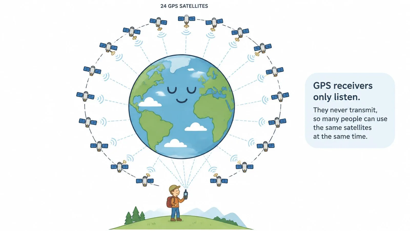
A GPS receiver only listens. It never transmits anything back to the satellites, which is why unlimited phones, watches, cars and aircraft can share the same signals at once without crowding the system. According to GPS.gov, the nominal GPS design calls for a 24-satellite constellation, while more than 30 satellites have commonly been operational at once. Each satellite keeps an extremely steady clock on board, and every signal it sends is a one-way broadcast carrying two pieces of information: where the satellite was and the exact moment the signal left.
The Three-Part Chain to Remember
Each satellite broadcasts where it is and exactly when it sent the signal. Your receiver notes when that signal arrives, measures the gap, and converts the delay into a distance. Broadcast, compare, convert. Every position fix reduces to those three moves, and a clock measurement sits inside each one.
Map software comes last, drawing the dot on streets and landmarks only after the timing work is done. One distance alone cannot locate you: a single measurement places you somewhere on a vast sphere around that satellite, so you need distances from several satellites before the possibilities shrink to one point on Earth.
Getting those satellites into their orbits runs on timing too, since rockets can only depart during specific moments, a puzzle explained in why rocket launches need a launch window. Once you step indoors and satellite signals weaken, other methods take over. This overview from a navigation technology company lets you explore the technology behind indoor navigation to see how those systems fill the gap.
Question 1 of 5
Why can millions of GPS receivers all use the same satellites at once without the system getting overloaded?
How Satellite Signals Become a Position Fix and Everyday Use
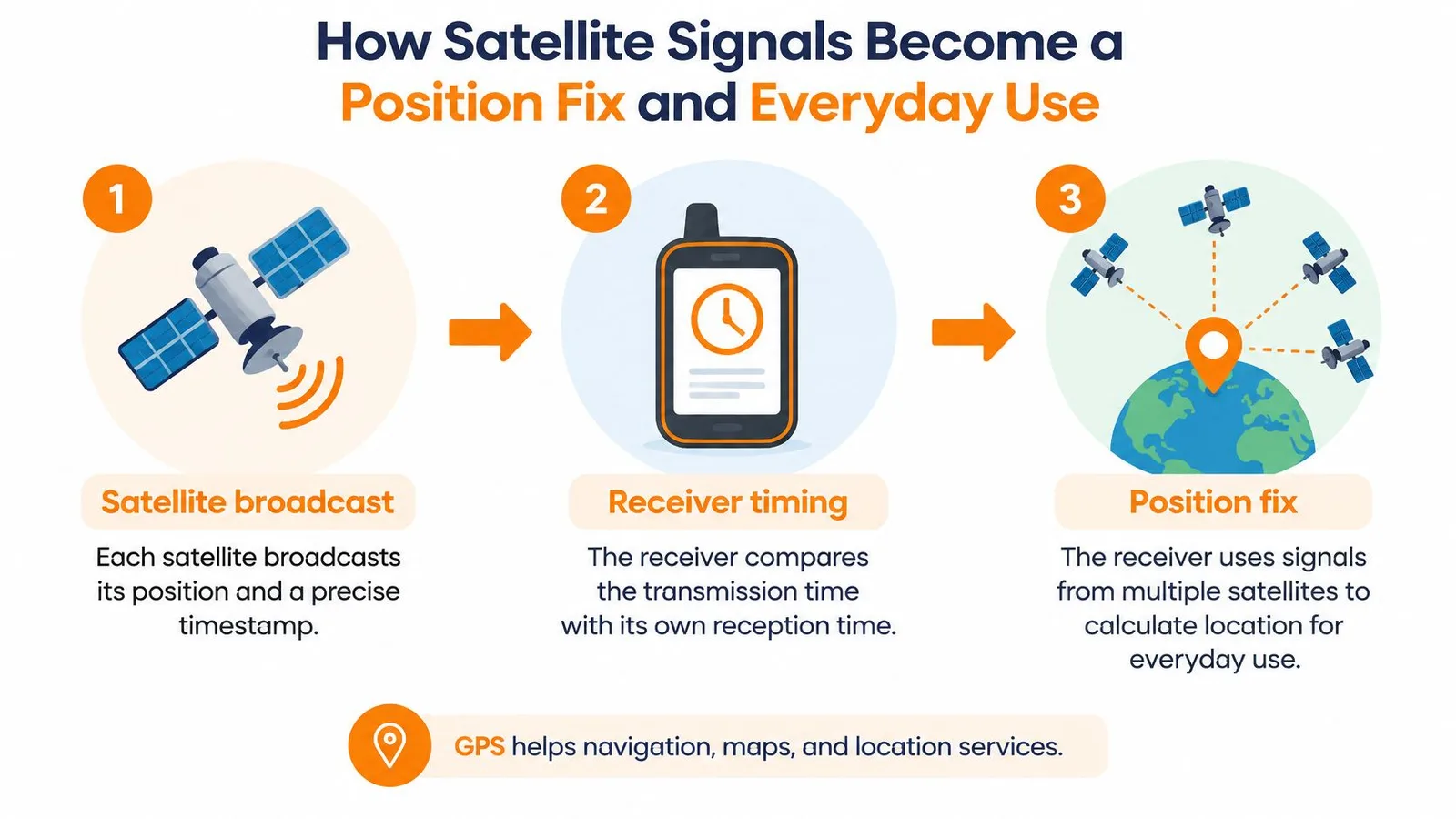
Say you're standing in an open field and turn on a hiking receiver. It doesn't ask the satellites where you are. It listens, timestamps what it hears, and does geometry. The GPS.gov explanation of trilateration describes a system that determines location by measuring signal travel time rather than by directly measuring angles, with each satellite broadcasting its position and a precise timestamp at the speed of light, 299,792,458 meters per second.
From Broadcast to Fix in Five Steps
- Satellite broadcast: Each satellite sends its position and a precise timestamp.
- Receiver comparison: The receiver compares that transmission time with its own local reception time.
- Distance calculation: It multiplies the elapsed time by the speed of light to get a distance.
- Sphere of possibilities: Each distance defines a sphere around that satellite where you could be.
- Intersection: The spheres intersect, and the common point is your location.
What each satellite count lets a receiver solve
| Satellites measured | What can be solved | Resulting position |
|---|---|---|
| 1 | One distance only | A sphere of possible positions |
| 2 | Two distances | A circle where two spheres meet |
| 3 | Three distances | Two candidate points in space |
| 4 or more | Three position values plus clock error | One three-dimensional fix with corrected time |
Readers often ask why three satellites aren't enough if three distances nearly pinpoint you. Geometry isn't the problem. Your phone's clock is. Satellites carry atomic clocks, but a phone uses an inexpensive clock that isn't synchronized with them, so every arrival time it records shares the same unknown error.
The fourth satellite solves that problem. Its measurement gives the receiver enough information to calculate latitude, longitude, altitude and its own clock error at the same time. In effect, every GPS fix also sets your clock straight. Extra satellites beyond four let the receiver pick the strongest, best-spread signals and cross-check the rest.
Where the Satellites Actually Fly
These signals come from medium Earth orbit, roughly 20,200 kilometers above Earth, where satellites complete an orbit in approximately 12 hours. They're spread across six orbital planes, and more than 30 operational satellites have commonly been available, so several are usually above your horizon. If a building or hillside blocks one, another often takes its place. The U.S. system became fully operational in 1993 after the first NAVSTAR satellite launched in 1978, so today's receivers build on a mature constellation rather than a fragile handful of spacecraft.
A useful mental model: GPS doesn't find you. It times signals so precisely that your position is the only place those timings can all be true at once.
Everyday Layers Built on the Same Fix
Phone maps rarely show your raw coordinates untouched. Apps use map matching to snap a slightly wobbly fix to the road you're most likely driving on, which is why the dot looks steadier than the underlying measurement. When you enter a tunnel, car navigation keeps going using dead reckoning, estimating movement from wheel-speed and motion sensors until signals return.
Fleet trackers work differently again. A device in a delivery van calculates coordinates plus a timestamp, then reports them at set intervals over a cellular connection so a dispatcher sees the route. The GPS part finds the position. The cellular part only delivers the news.
Some of the most important uses involve no map at all. Telecom and power networks use GPS time signals to keep distributed equipment synchronized, because a receiver that can solve its clock error is also an excellent source of precise time. Navigation is the visible product. Timing is the product underneath.
Question 2 of 5
Why does a GPS receiver need signals from at least four satellites to figure out where you are, when three distances would seem to pin down a point in space?
Why GPS Clocks Must Account for Relativity
A GPS receiver is basically comparing timestamps. It asks when each satellite says a signal left, when the signal arrived, and what delay explains the difference. Because that delay is multiplied by the speed of light, a timing slip of one nanosecond becomes about 30 centimeters of position error, and a few microseconds become kilometers. At that sensitivity, Einstein's relativity is daily engineering, not a classroom curiosity.
Every GPS satellite carries atomic clocks, but those clocks do not tick at the same rate as identical clocks on the ground. Two effects push in opposite directions. The NIST account of GPS and Einstein's relativity explains that special relativity makes a fast-moving satellite clock run about 7 microseconds slower per day than an Earth-based clock, while general relativity makes it run about 45 microseconds faster per day because gravity is weaker at orbital altitude, for a combined gain of approximately 38 microseconds per day.
Daily relativistic clock effects on a GPS satellite
| Effect | Direction | Daily clock change | Position error if ignored |
|---|---|---|---|
| Special relativity (satellite speed) | Clock runs slower | About 7 microseconds | About 2 km per day |
| General relativity (weaker gravity) | Clock runs faster | About 45 microseconds | About 13.5 km per day |
| Net combined effect | Clock runs faster | About 38 microseconds | About 11 km per day |
Why 38 Microseconds Is Not Small
Thirty-eight microseconds sounds like nothing in daily life. You could not blink that fast. Light travels about 11.4 kilometers in 38 microseconds, so an uncorrected clock offset of that size becomes kilometers of ranging error. Left alone, the offset keeps accumulating, producing roughly 11 kilometers of position error per day from the combined daily effect. A map can still look confident while the dot drifts off the street, the runway or the shipping lane.
Engineers remove most of this before it reaches you. Satellite clocks are pre-adjusted for the predictable part of the relativistic shift, and ground operators continually manage their timing afterward. Your receiver never asks you to think about curved spacetime. It receives timestamps that already carry the correction.
That is the chain running through GPS: clocks, timestamps, ranges, position. The system works because timing is measured to the nanosecond scale, which is what makes meter-level positioning possible under good conditions. A sky full of satellites cannot rescue a receiver whose clock model is wrong, and a clean view cannot help if the signal arrival times are distorted. Trust starts with time.
Question 3 of 5
Why would your GPS be off by 10 km per day without relativity corrections?
Real-World Accuracy and What Shapes It
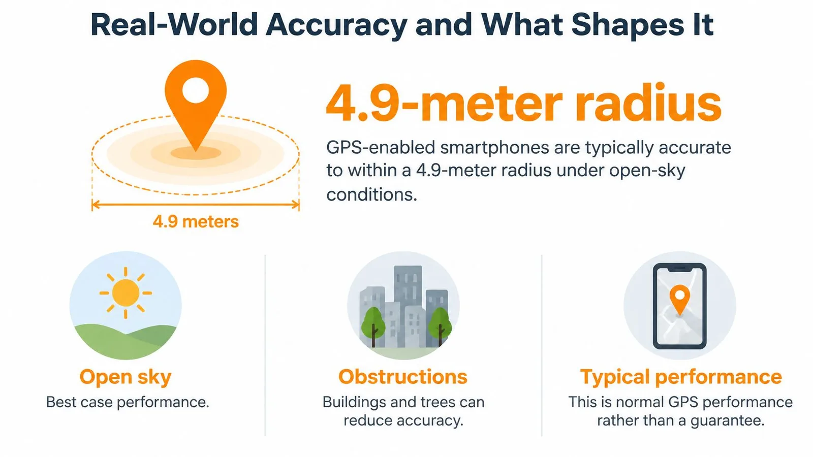
Under a clear sky, performance is good. GPS.gov reports that GPS-enabled smartphones are typically accurate to within a 4.9-meter radius under open-sky conditions, a figure published on its GPS Accuracy page updated in 2025. Treat that as typical performance, not a promise. Your surroundings can move you far from that best case.
Typical GPS accuracy by condition
| Condition | Typical accuracy | Main reason |
|---|---|---|
| Open sky, smartphone | Within about 4.9 m radius | Clear view of many strong signals |
| Dense urban streets | Often poor enough to sit on the wrong street | Buildings block signals and reflect them (multipath) |
| Under tree canopy | Degraded, fewer usable signals | Foliage weakens and scatters signals |
| Indoors | Usually no reliable fix | Signal too weak to decode without other sensors |
Five Things That Push Your Dot Around
- Poor satellite geometry: When visible satellites cluster in one patch of sky, their spheres intersect at shallow angles and errors stretch out. A wide spread across the sky cuts those intersections sharply, like locating a point with well-separated landmarks instead of three standing shoulder to shoulder.
- Multipath reflections: Signals bounce off buildings, cliffs or water before reaching you. The detour adds travel time, so the receiver thinks that satellite is farther away than it is.
- Atmospheric delay: The ionosphere and troposphere slow signals unevenly as weather and solar conditions change. Dual-frequency receivers correct much of the ionospheric part by comparing how two frequencies were delayed differently.
- Simple obstruction: Tree canopy and dense urban canyons reduce the number of usable signals, forcing the receiver to work with weaker, worse-spread measurements. Earth's rotation underlies satellite geometry over your day, a dependence made vivid by considering what would happen if the Earth stopped spinning.
- Being indoors: Roofs and walls usually weaken the signal below what a receiver can decode, so phones fall back on Wi-Fi, cellular and motion sensors instead.
In cities, multipath is often the largest source of error. When your dot drifts sideways between parallel streets or jumps across a river, the receiver probably isn't broken. It's faithfully timing signals that took a reflected path, and honest timing of a dishonest route still gives a wrong answer.
Question 4 of 5
Why can a phone's GPS pin be accurate to about 4.9 meters in an open field but drift much farther off on a tree-lined city street?
Jamming and Spoofing Can Fool a Receiver
A GPS receiver is trusting by design. GPS is a timing system first: it measures when each satellite signal arrives, then turns tiny timing differences into a position. If the arrival times are honest, the math is excellent. If the timing is manipulated, the same math can produce a confident lie.
Jamming is the cruder attack. A jammer floods the same frequencies with noise until the faint satellite signals are buried, and a receiver cannot decode arrival times it cannot hear. The result is honest failure: the fix drops, the device complains, and you know the system is blind.
Spoofing is quieter. A spoofer transmits counterfeit signals that imitate satellite timing, so the receiver keeps solving the normal equations with false inputs. It does not need to order the screen to show the wrong city. It only has to make a set of arrival times line up with the wrong place. Maritime authorities have reported jamming and spoofing affecting ships in several regions, which makes this more than a phone-map nuisance.
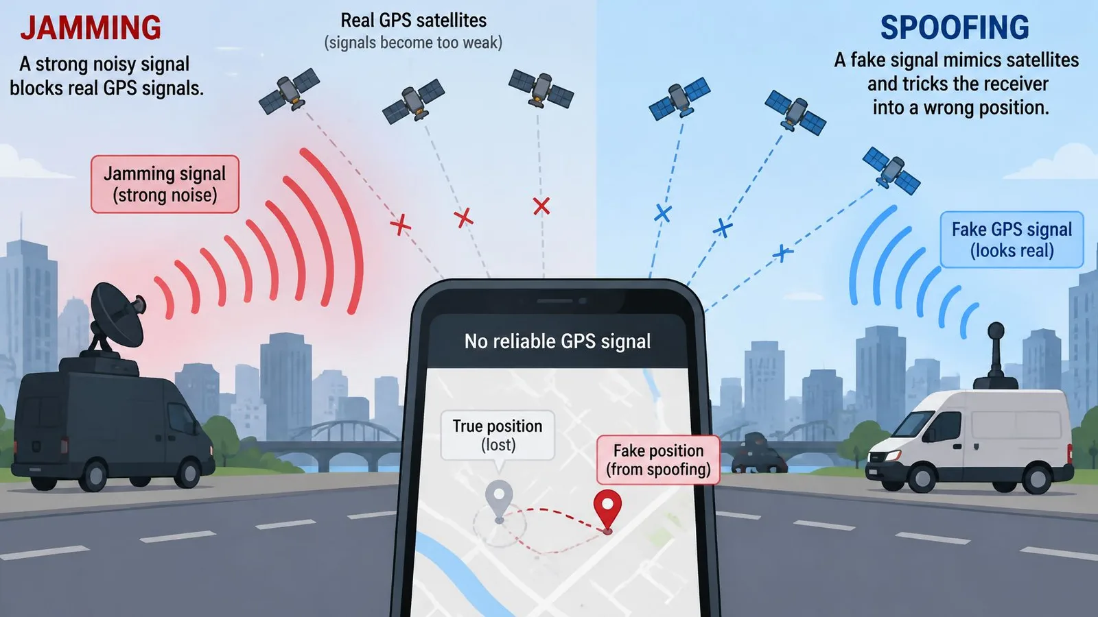
Aboard a ship, the stakes sharpen. Its automatic identification system broadcasts the vessel's position to nearby traffic and shore stations. If counterfeit timing feeds that system a manipulated location, the ship keeps transmitting a confidently wrong position to everyone relying on it for collision avoidance. No error banner appears. The display shows healthy satellites, a steady fix, and a ship somewhere it is not.
How Devices Check Whether a Fix Is Believable
- Inertial sensors: Accelerometers and gyroscopes track motion between fixes, so a reported path that the motion sensors never registered looks suspicious.
- Map matching: Software compares a fix with known roads and terrain. A car reported in the middle of a lake or inside a building probably is not there.
- Cellular positioning: Cell towers provide an independent, rougher location. A satellite fix that disagrees wildly with that estimate deserves doubt.
- Multiple constellations: Receivers listening to several satellite systems can spot when one system's answer is outvoted by the others.
- Signal-quality monitoring: Genuine signals arrive faint and consistent. Abnormal power or timing patterns can flag a transmitter much closer than orbit.
- Consistency checks over time: Position should change continuously, so software can reject jumps that outrun physically plausible motion.
These cross-checks reduce risk. They don't guarantee a fix is authentic, and any system claiming certainty is overselling.
The timing chain ends in trust. A location is only as dependable as the arrival-time measurements behind it and the cross-checks that challenge them. For drivers, pilots, ships and emergency services, that judgment matters as much as the fix itself.
Question 5 of 5
How does GPS spoofing make a receiver report a wrong position without any error warning, when jamming just makes it lose the fix?
Check Your Fix Before You Trust It
A phone that briefly places you across the river probably isn't broken. It rebuilt its timing solution on bad inputs, and the position came out wrong because the clock readings were skewed, not because GPS stopped working. Before blaming the device or trusting the dot, run through a few quick checks.
A Quick Checklist for a Suspicious Dot
- Check your sky view first: Step away from tall buildings, dense trees or covered structures, and go outside if you're indoors. A fix taken under a metal roof is built on reflected or blocked signals, so the timing math underneath it was compromised from the start.
- Give a cold start time: A receiver that's been off, or traveled far while off, needs time to find satellites and settle its clocks. Judge it after a fair chance outdoors, not in the first seconds.
- Compare a second source: Match the position against a visible landmark, a street sign, a known address or a cellular-based location in another app. Agreement between independent sources is reassuring.
- Read the pattern, not the dot: One stray jump means little. Errors that drift, jitter or sit stubbornly in the same wrong place point to multipath or interference, while clean recovery in open sky suggests the receiver is healthy.
- Calibrate your expectations: In good conditions, accuracy within a few meters is normal, so a dot across the street is unremarkable. Large or persistent offsets are the ones worth investigating.
If the fix still looks wrong after these checks, move to open ground and let the receiver rebuild its timing solution from scratch. Most everyday errors clear once it locks onto clean, direct signals and has time to average out noise in its clock measurements. Restarting location services can force that fresh acquisition when stale data lingers.
GPS is reliable for most everyday needs, from road trips to finding a trailhead to timestamping a delivery. It earns that trust by failing in understandable ways. Because position is really measured time, anything that corrupts the timing, reflections, blocked sky or counterfeit signals, corrupts the fix. Read it with high confidence under open sky and extra caution everywhere else.
If questions like why GPS needs multiple satellites spark your curiosity, Million Whys turns that wondering into a daily 10-second why-question with explanations for every answer choice, correct or not. Visit Million Whys to try today's question, follow a follow-up rabbit hole into trilateration or relativity, and build your own map of what you've learned.
Keep Exploring

Related Posts
How Do Noise Cancelling Headphones Work
Learn how do noise cancelling headphones work — from destructive interference to hybrid mics and the real limits of ANC explained.
Technology Trivia Questions and Answers
Technology trivia questions and answers about GPS, passwords, AI, mirrors, spam filters, sensors, and the everyday systems hiding in plain sight today.
How Does Gravity Work on Earth? Causes and Examples
How does gravity work on Earth? Mass, distance and the 9.8 m/s² pull explained, with everyday examples from falling objects to ocean tides.